“You’re just too late”, said the broad-shouldered resident of Katwijk, as he sat fishing opposite the Northgo door factory. “My mate just caught a seven and a half kilogram pike”. The other man, equally broad-shouldered, grinned triumphantly. Without even removing the cigar from his mouth, he took out his digital camera and indeed, the tiny screen showed him standing with a monster of a fish in his arms. “We put it back straight away of course, it’s all about the sport.”
At the mouth of the Old Rhine, the water is fished so heavily that the pike have become spoiled. They no longer show any interest in artificial bait; they’ll only bite these days if the hook is baited with a real fish. And so the men buy frozen sardines at the local supermarket because although Katwijk has its own fishing fleet, its homeport is IJmuiden.
Since 1163, when the mouth of the river became totally silted up in a storm tide, Katwijk has no longer had any real access to the sea. Although a plaque on the lock gates states that in 1807 ‘the joining of the Rhine and the North Sea’ was completed, the opening is so narrow that even the smallest boats from the nearby yacht marina are unable to pass through.
As a river, the Old Rhine is just as artificial as the double row of conifers facing the two fishermen. The trees, trimmed into the shape of giant lollypops, are intended to soften the lines of the grim view of the Northgo factory. And the Old Rhine is no stranger to window dressing. Although the water does flow to the sea, that flow is anything but natural. Indeed, pumps determine when and how much water is discharged making the Old Rhine no longer a river, but a storage basin.
I would always advise following a river downstream, from source to mouth, but since a storage basin knows no direction, the choice is entirely yours. My decision was based on the cold westerly storm. I started in Katwijk, for the entire 63.2 kilometre walk the wind was in my back.
New money
It turns out that the Old Rhine has an almost infinite number of different faces; it is home to rusty sheds alongside shiny ‘farmlets’, old boatyards alongside stately country estates, untidy allotments next to perfectly trimmed lawns. The hinterland, with its geometric forms on both sides of the river, represents a schoolbook example of Dutch spatial planning, whilst the ribbon development along the Old Rhine itself has a more Belgian aspect.
It all starts at the bridge joining Katwijk and Rijnsburg. This point is officially known as the Additional Canal. As you turn to the four compass points, you are presented with four panoramas which seem to have no relation to one another. On the south-east bank a row of greenhouses, on the opposite bank the greying halls of ’t Ambacht industrial estate; turn 90 degrees further and you are faced with a row of white houseboats, and opposite them, a dismal six-storey block of nineteen-sixties flats.
A little further on in Rijnsburg, or maybe you are already in Oegstgeest it’s difficult to tell in this urban conglomeration a villa, with decorative fencing in the neo-roman style looks out at a rusty boat raised on blocks, that has found a resting place amongst the decaying greenhouses of The City of Glass. A few hundred metres further on is evidence of the power of money. A driveway with cast-iron gates leads to a private stable. Spelled in the style of the nouveau riche, the sign announces proudly ‘Rijnweyde’.
Moving on towards Leiden, it is almost impossible to actually reach the water. At this point, the Old Rhine has traditionally had no function for inland shipping, and the back gardens run down to the river’s edge. Luckily for us, that Dutch habit of leaving curtains wide open makes up for these obstacles. Looking right through the houses, you see riverside views perfectly contained within a window frame.
Most of the new building projects compensate for this historical omission with the construction of a ‘new-style’ towpath. Often a narrow strip of asphalt, whilst occasionally, the designer was unable to resist the temptation and opted for a winding brick pathway. Briefly you can follow the actual riverbank, until you come across an industrial estate, a row of old terraced workers’ cottages or another area under glass, that forces you yet again to make another detour. Not until you reach the ancient city centre of Leiden can you once again follow the course of the former river, taking in various sites including the ‘Oude Rijn Graan Magazyn voor den Armen 1754’ (Old Rhine Grain Warehouse for the Poor).
Lowland plateau
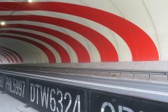
Cows. My nose suddenly picks up the unmistakable scent of cows. I left the viaduct over the A4 motorway behind me more than fifteen minutes ago; the ribbon of houses in Leiderdorp has by this stage started to trail off, and this smell marks the definitive end of any doubt. The Old Rhine has reached the Green Heart. Invisibly, the route of the HSL train link crosses the Old Rhine at this point. In the last few years, a more than seven kilometre-long tunnel has been bored beneath this landscape, to retain its open structure. The ‘longest tunnel ever built in soft soil’ cost almost half a billion euro, and at the time was the showpiece of famous Dutch poldermodel.
Even without this knowledge, the tremendous extent of this green countryside is impressive. After the jumbled, overbuilt views of the ‘sand lands’, you have a sense of entering a highland plateau or more accurately a lowland plateau, because these grassy plains are well below the water level of the Old Rhine. Only the railway line and the N11 are higher; both transport axes run along a dyke, so that the constant flow of cars and the incidental yellow train flash past high above natural ground level.
The farm buildings radiate a sense of power. Ancient espaliered limes, with their knotted fingers, stand guard. They harmonise remarkably with the decaying roof tile factory, with its wonky chimneys, the high, dust-ridden warehouses of De Hoop, and the silos of the Koudekerk Concrete Plant. These industrial behemoths are not only linked to the water; just like the farms, they form part of the physical world of production.
Less easily placed are the box-like distribution warehouses of store chains Trendhopper and Seats and Sofas A Giant Take Away. Surely these ‘superstores’ have nothing to do with the Old Rhine. Their only reason for existence is the presence of the N11 trunk road, that guarantees a constant supply of consumers. Indeed, these box-like structures have turned their backs on the water. Their only use for the dockside is as handy parking space. And the result? The charming white stuccoed villa Rijnzicht (Rhine View) does not look out on the Rhine, but instead the sombre back wall of Kagie Keukens kitchen suppliers on the opposite bank, whilst the two picnic benches squeezed into the narrow strip of green with its espaliered limes offer a panoramic view taking in the car park of the Kwantum home improvement mega store.
When it comes to protecting the natural beauty of this piece of the Green Heart, the hundreds of millions of tax payers’ money would probably have been better spent burying the out-of-town furniture outlets underground, instead of the high speed rail link.
Free passage
One small section of the Old Rhine forms part of the continuous shipping route from Amsterdam to Rotterdam. To be precise, the four kilometres that flow through Alphen aan den Rijn. In the north, the ships enter the city at ‘s-Molenaarsbuurt whilst a huge blue signpost at the southern end of Alphen directs river traffic right, onto the Gouwe.
Only the occasional boat continues on along the former river. If as many as one boat a day passes him, then bridge keeper Gerrit Houtman is more than happy. From his glass bridge keeper’s house in Zwammerdam, he operates all the bridges as far as Bodegraven. Officially he should lower the sun blinds so he can keep a better eye on his monitor screens, but the views are just too appealing. Right in front of him is the storage silo of NM Animal Feed. “The silo is still used, but the raw materials arrive by truck these days, and the same goes for timber merchants PontMeijer, on the opposite bank. As for kerosene from the port of Rotterdam, that today travels by pipeline to Schiphol.” What he really means is that business is dwindling, but it’s not something he wants me to put down in black and white; after all, he still has twelve more years until his pension. This is where the storage basin is at its most beautiful. Along this entire stretch, a towpath leads you behind rows of terraces workers’ cottages through open landscapes and past ancient farmhouses. The path sometimes becomes lost in the grass but everywhere the passage is free, with not a single back garden barring your way. From afar, at right angles to the river you see the line of four ancient windmills, turning at full power to discharge water into the Old Rhine. So much magnificent Dutch heritage should not be passed by, unremarked, hence the no less than eight signposts proclaiming ‘This information is brought to you by the Western Market Gardening and Agricultural Organisation’. A short distance further on, a decaying boatyard, a road construction firm and a new housing estate make sure that the overall aspect does not become too idyllic.
At the Bodegraven locks, the Old Rhine makes a leap of eighteen centimetres, and at this point you enter the jurisdiction of a new water board, the Stichtse Rijnlanden. Here, on the rebound, the Old Rhine starts to meander and if occasionally one bank maintains its straight line, the other makes gentle curves. In the bends, the westerly wind seems to force the water up against the riverside giving the impression that the short, sharp wavelets are treading water. Here, the towpath has been upgraded to a asphalt cycle path, along which hoards of schoolchildren rush homeward bound, their faces red from the wind beneath their blond hair.
Barrier
With a clarion call, the Old Rhine at Woerden affords one last glimpse of its industrial past. The river has narrowed here, as it flows between high factory walls, that take you back to the glory days of the industrial revolution. The bronze statue of boat towing harks back to the days before the invention of the steam engine.
And then the Old Rhine comes to a dead end, because Woerden filled in the former river in 1961. The only reminders of its old course are the Havenstraat (Dock street) and Rijnstraat (Rhine street). However, the canal section has not been filled in, so the water of the Old Rhine can once again be found on the eastern side, here, too graced with a bronze figure. Figurative art is popular in the polders. This statue represents three skaters with backs bent. I came across a near identical statue when leaving Katwijk.
From Woerden you join an official route. For pedestrians the Floris-V trail, or for cyclists the Haarzuilensroute, the Roman Route or the Linksom-rond-de-Domstadroute (Anti-clockwise round the Cathedral City Route). To make life easy for the recreational day-trippers, a wooden bridge has been built over the water a fixed bridge that no real vessel can pass beneath. The presence of such a bridge in the end makes all the lift bridges you come across further on a little ridiculous. However, the railway viaduct just before you reach Harmelen forms an even lower, and even heavier barrier. Together with the high-voltage cables that cross the water here, this sparkling white viaduct degrades the Old Rhine to the status of mere ditch.The landscape is beautiful with stately farmhouses, green pastures and pollarded willows. And the local residents are pleased to live here, too; so pleased indeed that slowly but surely with garden tables, coloured gravel and wooden decking, they are taking possession of the towpath, subtly suggesting that what you are walking on is their private property. Others have screened off their rear view with a head-high wall or conifer hedge, reducing the towpath to nothing more than a narrow passage. And at Burggraaf Builders, at Dorpsstraat 113 in Harmelen, the path reaches its definitive ending, at a raised fence.
Luxuriant jumble
The Old Rhine itself also ceases to be in Harmelen. Beyond the Haanwijkersluis lock, the water is known as the Leidsche Rijn (Leiden Rhine) and this stretch was indeed never a river. This water course was excavated at the end of the 14th century, in order to open up the land on the east of Utrecht. Today, it is the location for the largest new building project in the whole of the Netherlands: 30,000 homes, 700,000 m2 of office space and 280 hectares of industrial estate.
Here there is no separate towpath that leads behind the houses and creates its own, secret inner world. On either side of the water you find an ordinary road with farms, terraced housing, and shops. In other words, traditional ribbon development. And yet this road still retains the intimacy of a towpath. It acts as a buffer against the massive VINEX urban development location advancing beyond it; it remains a narrow retreat where the past is kept alive; a jumbled, untidy ending, in a uniform, modern world. But this untidiness conceals luxury, because it’s where everyone wants to live, and at witnessed by the ‘for sale’ signs, many of the former owners have obviously decided to cash in on the boom. Here, the traditional pluriformity of the former river rich and poor, living and working, chaos and order is under considerable pressure.
Published in: Focus Locus Oude Rijn